OK. So you’re thinking. American Samoa! What could possibly
possess them to go below the Equator to that South Pacific island? Well,
believe it or not, as a United States territorial possession, there is a
national park, specifically, the National Park of American Samoa located there,
and it is on the list of 59 parks to visit. Why are we visiting now?
Well, that’s
a little longer story that goes back to our visit to Wrangell-St. Elias N.P. in
Alaska. Last year, being Honda Goldwing owners, we joined the Goldwing
motorcycle club in Baton Rouge. A small group of club members were planning a
trip to the Hawaiian Islands and asked us if we would like to go with them.
Hawaii was something on Jane’s list and we were signed up before Capt. Larry knew what hit him. Enter Wrangell-Elias N.P. While visiting this park we met a professor of ‘travel and ecology’ from the Detroit, MI, area, a Dr. Diane Pick. Diane was interested in our national parks bucket-list item as she had visited every one of the parks at least once, and may 2 or 3 times.
When she learned
that we were going to tour the Hawaiian Islands, she asked: ‘What about the
park in American Samoa? You are going to Honolulu and you have to go through
Honolulu to get to American Samoa. Well, we knew about the park and figured
that we’d get to it sometime, but she got us thinking. Since we were already flying
to Honolulu, it seemed to make sense, both time wise and economically to attach
a side trip down to the island. We got with our travel agent (who tolerates our
idiosyncrasies) and she changed our itinerary to include a swing down to the
island. We would leave a week before our other motorcycle riding brethren,
spend a week in American Samoa, then fly back and hook up with them for the
cruise of the Hawaiian Islands. Why a whole week? Well Hawaiian Airlines, which
is the only carrier from Honolulu to Pago Pago, only flies there twice a week-
on Mondays and Fridays. So we could fly in late on a Friday, have two days to
see everything the out on Monday, or in on a Monday and out 7 days later. We chose
the latter to give us time. So everything is so simple, right?
 |
| Surfer dude Duke Kahanamoku |
 |
| Sunrise on Waikiki Beach |
Hawaii was something on Jane’s list and we were signed up before Capt. Larry knew what hit him. Enter Wrangell-Elias N.P. While visiting this park we met a professor of ‘travel and ecology’ from the Detroit, MI, area, a Dr. Diane Pick. Diane was interested in our national parks bucket-list item as she had visited every one of the parks at least once, and may 2 or 3 times.
 |
| Beach life on Waikiki |
To get to American Samoa we had to fly to Honolulu, spend a
night, and then fly out the following afternoon. This gave us a little time to quickly sightsee Honolulu and
Waikiki Beach.
We arrived at the Pago Pago airport around 2130 and were met by
a shuttle that would take us to our hotel, Sadie’s by the Sea in the village of
Utulei.
We picked this hotel because it had a private beach, a bar and
restaurant, a gift shop, and because it had our granddaughter’s name in it-
Sadie. We had read some online reviews about the place, many of which spoke of
the devastation of the 2009 tsunami, but all indicating a great staff and nice
facility after the tsunami damage was upgraded. We weren’t disappointed.
Every place
we’ve stayed at has little quirks of some kind, and Sadie’s was no exception.
But all in all it was a great resort. We got settled in for a nice long rest,
but were up at the crack of dawn the following morning because of time zone
changes. The sun rising over the mountains surrounding Pago Pago Harbor were
absolutely gorgeous. We went walking, took our first swim in the Pacific Ocean,
and then spent some time by the pool.
 |
| Lunch at Sadie's |
 |
| Enjoying Sadie's pool |
 |
| Sunrise over Pago Pago Harbor |
American Samoa is a familiar place. It is American in that
the language, money, postage, etc. are the same as the mainland, but it is
still native and independent in many ways.
Most of the time we heard Samoans
conversing in their native language, but they could fluently start speaking
English to talk with us. And the thing we liked the best was that this South
Pacific island is not touristy by any stretch of the imagination. We had to
really search to find some post cards that featured the island, and ended up
sending the hotel’s postcards as an alternative. But we definitely liked the
climate.
It is situated in the South Pacific region of Oceania and is about
2600 miles southwest of Honolulu and about halfway between Honolulu and New
Zealand. It is one of two U.S. possessions, the other being Jarvis Island, in
the southern hemisphere.
At about 14°S latitude, the island is located approximately
halfway between the Equator and the Tropic of Capricorn which gives it an
equatorial tropical marine climate. November to February is Samoa’s rainy
period.
Temperatures are a little lower due to overcast skies, but the
temperature still got into the lower 80’s each day, and with the breeze it was
very comfortable. We seldom ran the air conditioner, it was that comfortable.
At 170° W longitude Samoans are among the last peoples to end each day as the
International Date Line, where tomorrow begins, is only about 100 miles to the
west.
 |
| Pago Pago's own zip code |
 |
| A beautiful Pacific beach |
 |
| The beautiful north shore |
 |
| Breathtaking! |
After our first day there we had two requirements; 1) where
to find some liquor, and 2) where to get a rental car. On our morning walk we
saw several convenience stores or markets that had beer, but no liquor.
When we
inquired as to where we might purchase some liquor, we were told: ‘Sadie’s by
the Sea Resort-’ the place we were staying.
Sure enough, we got back to the
hotel and found the gift shop and low and behold a liquor shop. How could we
have missed it? With that necessity taken care of, we went to the front desk
and inquired about where we would have to go to get a rental car, thinking that
the nearest agency was back at the airport. Nope! Sadie’s also rents cars. We
selected a Toyota RAV/4, and off we went.
Our first mission was to go to the
American Samoa National Park visitor’s center and collect the stamp, then head
out and see the park. We found that the 2009 tsunami had totally devastated the
visitor’s center and everything had been rebuilt.
The ranger on duty filled us
in about the park and we watched a couple of videos and viewed the exhibits
before heading out. The park is actually located over three islands that are
all part of American Samoa. But they are all about 60 miles apart and the only
way to visit the other two islands is by plane (a boat does make a once-a-week
run, but it’s impractical to see them by boat).
So we were pretty much
relegated to seeing the park on the island of Tutuila. But this wasn’t bad at
all. We drove over the island’s main ridge of mountains and were agape at the
stunning scenery we were looking at. The bays and inlets at sea level are
breathtaking, but the views from altitude are even more stunning. After seeing
the park, we headed back to our room to relax and chill out.
 |
| Almost there |
 |
| Getting the STAMP! |
 |
| We made it! |
 |
| View of a north shore bay |
 |
| The Cock's Comb |
We like to walk every morning for exercise and to explore
the area, and had read warnings about the number of dogs roaming Pago Pago in
packs which could bite or attack.
We did see a large number of dogs, but none
of them were threatening. One thing we did notice about the Samoan dog
population was that all of the dogs looked like they came from the same litter.
They all looked to be of the same breed- Samoan mongrel, and were all almost
identically sized, colored, marked, and had the same disposition.
We began to
think they were all descended from some great Samoan chief’s dog. Mostly we
found the dogs to tolerate us well and basically lie in the sidewalk and make
us walk around them.
There was one special dog, however. Every morning when we
walked past the hardware store we saw this dog resting on the sidewalk. It resembled
Labrador retriever and was the only dog we ever saw with a collar that was
embroidered with her name- ‘Molly the Tool Shop Dog.’ We said ‘hi’ to Molly
each and every day we passed her.
 |
| Samoan mongrel |
 |
| They're all alike |
 |
| Our favorite, Molly |
 |
| The Tool Shop Dog! |
Our walks generally took us around Pago Pago Harbor, a deep,
natural, well protected harbor surrounded by high mountains that provide
protection from the wind.
The harbor is home to a stevedoring company that
maintains fishnets for the tuna boats. Every morning we would pass this
operation and see the workers repairing, making, and readying the nets for the
fishing boats.
On our second day, a Holland America cruise ship on a 60-day
South Pacific cruise docked at the Pago Pago terminal. Local merchants set up
an open air market that had Jane salivating, but the market was in a restricted
area for the passengers and we were not allowed to enter. Jane was disappointed
she couldn’t spend her money.
However, we spoke with many of the passengers who
were looking for a mall that was a map they were given that we were pretty sure
did not exist.
We had walked the route before looking for places to shop and
couldn’t find any. Not believing us, some wandered on for a considerable
distance before giving up and having to endure the smirks on our faces when
they passed us again.
We learned that Pago Pago is not a common stop for
cruised ships and only about 18 a year pull into port.
Our walking route took
us to the head of the harbor where a number of sailboats were moored. We saw
flags from Canada, Japan, and the U.S., and Capt. Larry began wishing he were
younger and could do that kind of adventure. Our route would end at the Star-Kist® Samoa tuna processing plant
where they would process and can tuna for export.
 |
| Tuna nets ready to go |
 |
| Containers ready for shipping |
 |
| Cruising to somewhere |
 |
| Tuna boats in the harbor |
 |
| The tuna plant |
 |
| An NFL Charlie the Tuna |
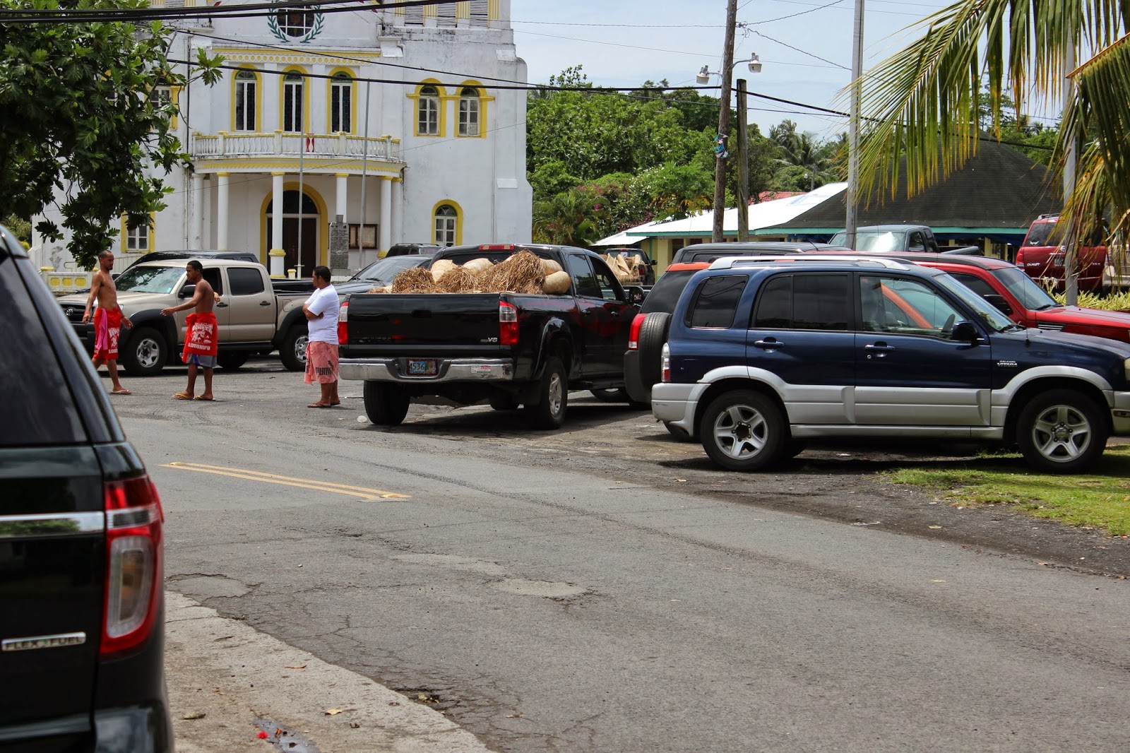
American Samoa is about 5 miles north to south, and about 20
miles east to west making it slightly larger than Washington DC, with
approximately 60,000 inhabitants.
There is one major highway that runs east to
west with north-south offshoots at intervals. Traffic is a headache with the
maximum speed limit on any of the roads set at 25 mph. Most of the population
gets around by private buses that are pickup trucks that have been stripped
down and an open air bus body added.
Being private concerns, they are quite
colorfully decorated in religious, island, or NFL football themes. Speaking of
football. We noticed that several fields near the schools were being used to
practice football.
Samoans are naturally big people, and their youth are
finding that the way to the big time is to practice and play football well so
they can get scholarships to major American universities with the hopes of
eventually making it into the NFL. Samoan players are currently found throughout
the NFL and for many, it is their ticket to fame and fortune. We headed toward
the western end of the island with the intent of driving the road to its end at
the little town of Fagalamo.
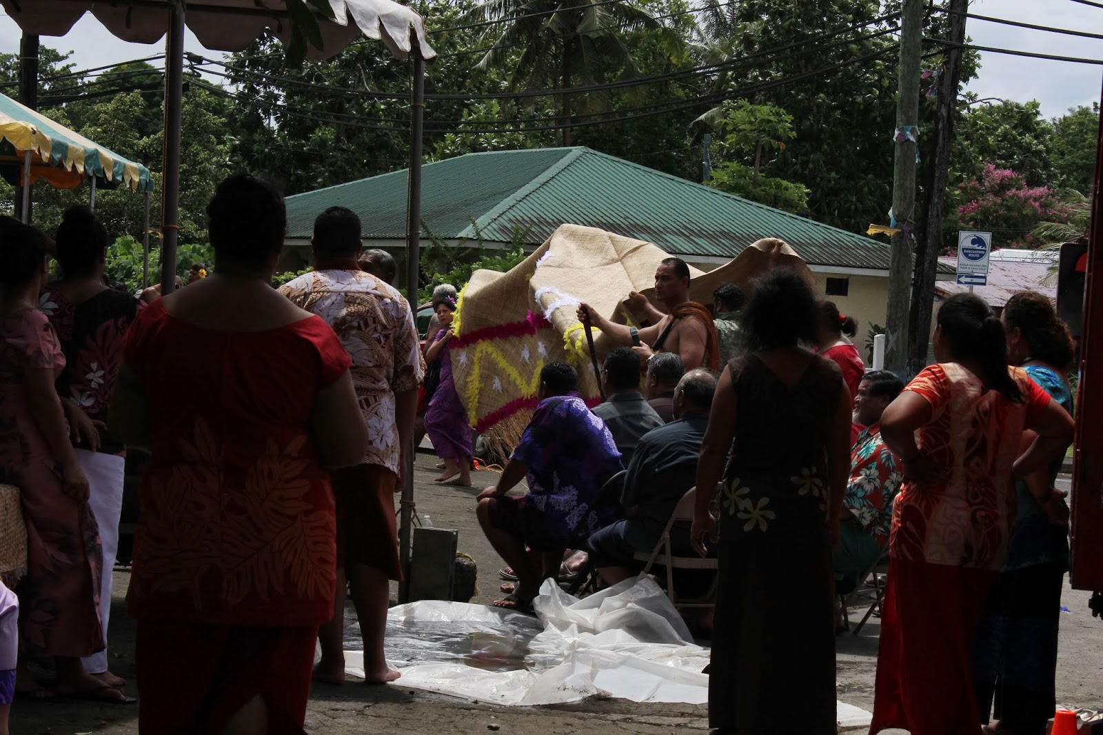
We got to the village of Leone, the second largest
town on the island, and we saw a local native festival being celebrated right
next to a catholic church.
We stopped to see what was going on and were
informed that it was a ceremony for the restoration of a title.
There was an
older chieftain looking person with headdress that everyone seemed to be paying
homage to. And homage was paid by presented these woven reed mats that were
painted and decorated by various families in the community. And there were
hundreds of mats. There were crews of men who would unroll the mats from their
storage location, and younger members who would present the mats to the head honcho.
This went on and on with an occasional break for a dance by some of the women. We
learned later that the mats were originally used as money in the Samoan culture
and giving a mat was a special way to show respect. We watched this ceremony
for about one-half hour then headed down the road toward Fagalamo. To get to
Fagalamo we had to go over some mountainous roads (or cow paths) that were
really challenging.
Once we arrived we were on the north side of the island and
the view and scenery were stunning. We took all of this in for a while then
made our way back to our hotel where we decided to sit by the pool.
Unfortunately, our pool experience was cut short by a group of loud, obnoxious
Russian youths that drank too much and were way too raucous. In our travel
experiences we have always found the Russians we encounter to always have a
high decibel bravado that we interpret as an attempt to convince everyone
present that they are still a superpower. We left the pool area and went to the
beach where Capt. Larry swam in the Pacific Ocean for the first time. After
cleaning up, we had dinner at the hotel and turned in early.
 |
| Converted Toyota pickup bus |
 |
| Buses at the bus depot |
 |
| Title restoration ceremony |
 |
| Hauling out the mats |
 |
| Honored dignitaries |
 |
| And more mats.... |
 |
| Road to Fagalamo |
 |
| View outside Fagalamo |
 |
| Ubiquitous warnings of where you are |
The next morning we decided to take the major highway east to
its end at Onenoa. The western part of Samoa has higher peaks getting a lot
more rain with rain forest areas scattered around that end. The eastern half
has lower mountains, but beautiful tropical sandy beaches all the way to its
easternmost tip.
At Aua we headed across the ridge to the little community of
Vatia. The northern shore is absolutely breathtaking. Back across the ridge we
continued on to Faga’itua where we again shot across the ridge to Masefau. Back
to the main road and on to Tula before ending at Onenoa.
All of these villages
were quite picturesque. We were amazed by the number of churches that were
supported by these little villages. Every village had 3 or4 churches that we
were adamantly informed were supported locally and not by missionary
contributions.
There were so many churches that we are posting a separate
gallery of the churches of American Samoa (and by no means did we get them
all).
To see the gallery, follow this link : Churches of American Samoa We needed to do some laundry and
were going to stop at a laundromat in Pago Pago. But on our return trip Jane
spotted a laundry on a stretch of sandy beach. We stopped and did the laundry
while we took in the beach and the South Pacific.
 |
| A village church |
 |
| View near Faga'itua |
 |
| A north shore church |
 |
| And another |
 |
| Finding coconuts while doing laundry |
 |
| The funeral store |
 |
| Front yard grave sites |
 |
| Grave by the carport |
 |
| Fancy grave with picture headstone |
 |
| A 'party hall' |
 |
| Another one |
 |
| Let the celebration begin! |
 | ||||
| A rainforest flower |
 |
| The island seen on Samoan license plates |


