Saturday, July 27, 2013

We Take an Intersting Side Trip


Green River is fairly close to the Utah/Colorado border and we headed that way the next morning. Almost immediately after we crossed the border we  noticed a change in landscape from the relatively barren, but colorful, sedimentary rock mountains in Utah to the alpine conifer forests that blanket Colorado’s granitic mountains.
Transitioning to CO mountains
We also started to increase our altitude rather dramatically.
We stopped in Grand Junction to refuel and made our way to the popular ski areas of Vail, Beaver Creek, Breckenridge, and Aspen.
Vail ski slopes
As we passed through the Vail Pass our altitude increase to over 10,000 feet. The mountain views were impressive, but we still favored the colorful beauty of Utah.
Ski resort
We arrived in Denver fearful that we would get caught in rush hour traffic, but even though we had to slow down considerably as the traffic volume built, we avoided any jams and were through that city in reasonably good time.
Rocky Mountain high
Just past Denver the landscape changes abruptly to the rolling foothills of the Rocky Mountains, and land utilization reverts back to agriculture and ranching. We were pressing our drive in an effort to get into western Kansas and a time change back to Central Daylight Time, so as to not lose an hour as we started the next day.
We're on the right road
When we got to Colby, KS, however, we decided to check into a motel as we just didn’t want to go any further, and we were just a short distance from the time zone change. Jane was driving the next morning and Capt. Larry was perusing the road map when he noticed a small town marked on the map named Pfeifer, KS. Since that is the exact spelling of our last name, and it didn’t appear to be too far out of the way, we couldn’t pass up a visit.
Could this be Pfeifer, KS?
As we exited I-70 at Victoria, KS, we spotted a large church that Capt. Larry must be Lutheran for all of the people of German descent in the area. The German part turned out to be accurate, but the church was Catholic. In fact it was a Catholic cathedral named St. Fidelis Cathedral (Cathedral of the Plains) and was proclaimed to be one of the 8 Wonders of Kansas.
St. Fidelis Cathedral
We couldn’t believe that we had stumbled upon this and we got really excited. Deciding to view the church when we came back from a visit to Pfeifer, we took Pfeifer Avenue south looking for the town. According to the map it was situated on the southern bank of the Smoky Hill River, so we were looking for a stream.
The cathedral sanctuary
Our atlas showed the town on the map, but didn’t list it in the index, so we figured that it had fewer than 500 people in it or perhaps was unincorporated, and we didn’t have good data service so we could look it up on our phones. We drove about 4 miles south of Victoria and came to an intersection by a stream that we assumed was the Smoky Hill River.
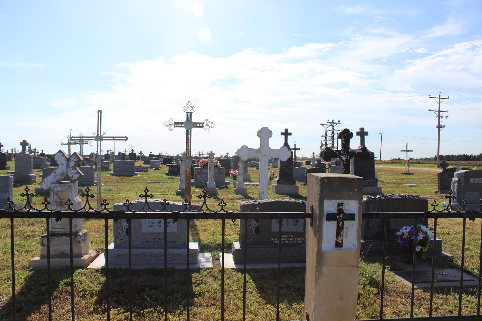
Wolgadeutsche cemetery
The distance looked right according to the scale on the map. But there was no town- just a couple of farm buildings and not much else.
Volga iron crosses in St.Fidelis cemetery
Figuring the town no longer existed, we took some pictures then drove a couple of miles further south just to make sure we hadn’t missed. We turned around and headed back to Victoria to see the cathedral. It was awesome and very well maintained, but it almost seemed out of place in this very rural and sparsely populated setting.
Michael, Larry, and Catherine Pfeifer
Jane took some pictures inside the church but forgot to reset the camera settings to take the indoor shots, so they didn’t turn out very well. We enjoyed the architecture that mimicked that of the church in the homes surrounding it. Just as we were ready to get on the interstate we spotted the catholic cemetery. Jane spotted some markers that looked like those in New Orleans and wanted to take some shots.
More beautiful markers
As she was shooting, Capt. Larry saw that some of the grave markers had very ornate metalwork which resembled that found in aluminum screen doors and something Jane had missed completely. As he pointed it out, we both became fully aware that we had happened upon a very old ethnic cemetery. We took pictures of the markers, then drove inside to see if we could find some bearing the Pfeifer name. Virtually every marker bore a German family name and it was obvious that large sections were devoted to single families. Toward the front of the cemetery we found the Pfeifers. And we found some very old Pfeifer family markers. Two of the markers bore the name of Michael and Catherine Pfeifer (both names in his family) who died in 1813 and 1819 respectively. Bear in mind that the Louisiana purchase occurred in 1803, so these were probably pioneer settlers. Also, the Pfeifer name is a very old German family name and is part of the language (we’re told it means “whistler” or “piper”) so it is very probable the there is a common ancestry.


We left the cemetery amazed at what we had stumbled upon and headed for Wichita were we had lunch and refueled. It was still early so we planned to try and make Arkansas before stopping for the night. Our route took us through Tulsa and then onto Ft. Smith where we checked into a motel. We decided to find a local restaurant for dinner and went down to the old, historic section of the city.
Beautiful clouds over Oklahoma
Here we found a restaurant called “Sisters.” The receptionist immediately asked us if we wanted to drink alcohol. We indicated that we did and were then asked: “Are you a member of the club?” We had no idea what she was talking about until she explained that it was a “dry” county and we had to be club members. Thinking that we would have to forgo any drinks or wine, she then presented a form that when filled out would make us club members! So that’s how they get around the stupid temperance. One has to wonder why have the law if there’s always a loophole. We had a nice meal, met the owner, and left just as a musician (with a banjo!) was getting ready to play. The owner begged us to stay, but we had had a very long day and elected to head back to our room.


ADDENDUM: When we got home we checked out Pfeifer, KS with Google and Google Earth. Turns out the town was not where we thought it was. It is located about 10 miles south of Victoria and we only went about 6. So close, but yet so far. It has a post office and zip code 67660. The 2010 census showed 81 people but the current estimate from the town’s database is 68 (it’s easy to tell who comes and goes!). Here’s a table of demographic data from the 2010 census:


Estimated Current Population:
68
Population:
81
White Population:
79
Black Population:
1
Hispanic Population:
1
Asian Population:
0
Hawaiian Population:
0
Indian Population:
1
Other Population:
0
Male Population:
45
Female Population:
36
Avg House Value:
$91,000.00
Avg Household Income:
$32,396.00
Avg Persons Per Household:
2.45
Median Age:
43.30
Median Age (Male):
47.50
Median Age (Female):
36.00


We thought this was kind of fun. Here’s some links we’ve found about Pfeifer for the few of you who are interested:


Info about the settlement of the town:             http://www.volgagerman.net/Pfeifer.htm


Parks #14 and #15- Death Valley and Great Basin


To get to Death Valley, N.P. from Pinnacles required us to circumvent the southern Sierra Nevada as there was no direct route through the mountains.
Mountains in the Mojave Desert
We headed down to Bakersfield where we stopped for gas and got lost in the process. After getting our bearings straight (resetting Jane’s compass!), we found the route to Mojave where we immediately entered the desert.
Desert billboards
And it was hot. We made our way to Olancha and connected with a route that would take us into the park. The ride into Death Valley was interesting as the road ascended to about 5,000 feet before plunging into the valley with altitudes below sea level.
At the rim of Death Valley
After we left the mountains, the road through the valley became as straight as an arrow with a steep decline. We progressed to below sea level and made it to Stovepipe Wells Village and the visitor’s center.
Looking down into Death Valleu
There was a thermometer outside the center that registered 111° IN THE SHADE! This temperature produced the mother of all hot flashes for Jane, and we hurried inside, collected our stamp and immediately got back in the car before it became overheated from sitting in the sun.
I'm finally here!
While we were in the center, Jane received a hand fan that advertised the centennial celebration of park’s record temperature of 134° set on July 13, 1913, and which currently stands as the hottest temperature ever recorded.
My makeup is melting
We were disappointed that we missed this torrid event. We also noticed that all of the glaciers have fully retreated, perhaps an indication that global warming is occurring in this environment. We had the GPS running which gave us our altitude and recorded a low point on the road of 80 feet below sea level.
Balmy conditions today!
Kinda made us think that we were in New Orleans. However, the lowest point in the valley is 270 feet below sea level (New Orleans in the future- just imagine the levees!), but that point is way off road and we weren’t in a hiking mood. We continued on, thinking we would have to come out at the eastern entrance to the park and take a long route to Beatty, NV to spend the night.
Along the Beatty shortcut
As we passed an offshoot of a road to the northeast, Capt. Larry remarked: “I think that road might be a short cut out of here.” We studied a park map that showed a road marked by a gray line (the gray line roads are always the most challenging) that did lead to Beatty. We decided to try our luck and pressed on. We immediately started an ascent out of the valley, but also knew that this was not a highly traveled road and, if we encountered any problems, we might be in trouble. Fortunately, after a 45 minute ride, we arrived in Beatty. However, it was still early (the shortcut worked!) so we pressed on to the next “big” town of Tonopah, NV. What an armpit this town is.
Why do we always do this?
We were immediately wishing that we had stayed in Beatty, but it was too late. What was amazing to us as we cruised through town, was that all of the motels were displaying “NO VACANCY” signs, as if everyone was flocking to this mecca. We passed by one establishment with a “VACANCY” sign on, but it looked kind of dumpy so we figured that was the reason. After a couple of more fully booked motels, we found ourselves at the edge of town. With the next nearest town was a couple of hours away,  it looked like we would be staying at the vacant Clown Motel (seriously). To make things worse, there was only one room left and it was a smoking room. Who really has smoking rooms anymore? Perhaps only in Harry Reid’s state. We weren’t happy, but felt we had little choice but to take it or spend the night in the car, a thought that was not necessarily unappealing. The motel’s ice machine didn’t work, and Jane would not take a bath in the bath tub (need we explain?).


We awoke the next morning coughing from the irritation. We packed the car and headed out to a Chevron station to get gas and something for breakfast. Jane entered a McDonald’s while Capt. Larry cruised the gas islands looking for gas pumps that were operative.
Big business in Tonopah
Fully one-half of the pumps were out of order. He found one that seemed OK, but after swiping his card, he found that the keypad didn’t work and he couldn’t enter his zip code to complete the sale. Finally he spotted a man and young boy coming from the restaurant to their car parked by the gas pump. Capt. Larry pulled up behind waiting for them to pull out. But no, instead of driving off these inconsiderate jokers swipe their card and start to pump gas! All of this after 15 minutes trying to get a pump that worked. He thinks he now understands why Nevadians voted the way they did in the last election. Jane emerged with breakfast and we drove to another gas station. From this point on we would spend as little of our dollars as possible in Nevada.
On the road to Ely
Tonopah is like so many other small towns we’ve seen. Outside of the tourist traffic (which explains the numerous motels with little availability) there seems to be no major revenue generating businesses that contribute to the tax base. The lack of economic activity seems to lead to residential decay with unkempt homes and yards, junk cars everywhere, and decaying buildings and abandoned business establishments. Kinda like a small scale Detroit. We think that people just give up when the community isn’t moving forward.


We gladly left Tonopah for a long ride through the Nevada desert on our way to Ely, NV and the Great Basin, N.P.
Another notch in Jane's belt
The ride was interesting as we encountered numerous homes, farms, and ranches which all begged an answer as to how they carved a living out of this environment. It certainly must not be easy, and our hats are off for their perseverance.
Bristlecone pine tree
We arrived at the park and found the visitor’s center where we collected our stamp, watched a long video, and viewed the center’s exhibits.
This is it. Great Salt Lake Basin
The Great Basin, N.P. has to be the strangest park we’ve visited. Basically it encompasses a part of the Great Salt Lake Basin and some surrounding mountains. While the park is in Nevada (probably due to politics), most of the defining feature, the Great Salt Lake Basin is squarely in Utah (we guess at five Utah already had its share of parks, so spread the wealth).
Entering another of our 20 states
There are some interesting habitats and ecosystems within the park with the alpine forest and bristlecone pines being the featured highlight. Bristlecone pines at altitude live to be very old trees (>1500d years) and their gnarled features are a beautiful nature display. We left the lower visitor’s center and made our way to the Lehman Cave visitor’s center higher up the mountains. Here we collected another stamp and had lunch in a picnic area, before heading back down to the valley and leaving.
Along I-70 in Utah


Shortly after leaving the park we entered the state of Utah and started to witness some really remarkable scenery.
Love the sediment layers
For quite a distance we drove through or along the Great Salt Lake Basin and saw some wonderful salt flats and mountain landscapes.
Looks like a mini-Grand Canyon
There were also some fine sedimentary rock formations carved by the water and wind, as well as mountains and buttes that presented astounding displays along the road.
Another Utah vista


Although the snowcapped mountains of Alaska were impressive in every manner, the mountains of Utah exhibited beautiful vistas that were just as awe inspiring. We got to Green River, UT and decided to stop for the night. It was an interesting day.


Resplendent Utah!


P.S. The retreating glaciers in Death Valley was a joke!


Wednesday, July 24, 2013

Visiting America's Newest National Park and the Land of Giants


Salinas Valley vegetable growing
Leaving Salinas, we passed through the Salinas Valley which is noted for its vegetable growing farms.
Where Jane's wine comes from
We were headed for Pinnacles, N.P. the 59th and newest national park.
Originally a national monument, the park was established in January, 2013.
It's a park now
We drove through the rich farmlands of the Salinas Valley before entering a more hilly and barren landscape.
Pinnacles rock formations
Pinnacles, N.P. features rock domes and formations created by volcanic activity along the San Andreas Fault.
Along the San Andreas Fault
In fact, we were going to view the western half of the formation with the eastern portion located approximately 230 miles to the southeast, a testimony as to how the two tectonic plates along the fault have moved in relation to each other.
Unusual rock outcroppings
The park was a surprise. We arrived at the visitor’s center after traveling along a one lane road for about 15 miles. At the center we collected the stamp, talked with the ranger, and watched a video about the park.
Dirt eating cattle
Then we headed down a narrow, winding road that took us to an area where we could see the pinnacles perched atop the high hills. Viewing the landscape around these formations, one realizes just how unique they are. We left and made our way back to Soledad, then headed into a really barren and hilly landscape on our way to Fresno.
Ever changing California countryside
The land looked as if it would not support any type of farming, but as we drove on, we saw some herds of cattle that appeared to be grazing on dirt! We could not determine any type of grass available, and wondered exactly what they were eating and how they survived in these conditions.

As we entered the rural outskirts of Fresno, "The Raisin Capital of the World,” we found more varied types of agriculture being practiced, although grape and plum orchards for the raisins and prunes seemed to dominate.
Park entrance
Passing through Fresno on the Kings Canyon Highway, we entered the fruit producing region of Squaw Valley where citrus dominates, and began a long, winding ascent up to the park’s entrance.
Walking through a big tree
The park consists of two sections- a smaller reserve containing a grove of giant sequoias, and a larger main section of the southern Sierra Nevada that is home to the canyon itself.
The trees are just huge!
Although many people view the giant sequoias at this park, it is actually named and noted for the canyon that was carved by glaciers during the last glaciations and more recently by the action of the Kings and San Joaquin Rivers.
The General Grant
We stopped at the visitor’s center, collected the stamp, watched a video about the park, and viewed the exhibits before heading out to Grant’s Grove to see the giants.
Us and the general
The General Grant, “The Nation’s Christmas Tree,” is the third largest tree in the world behind the General Sherman and President. It is approximately 270 feet tall, 40 feet in diameter at its base, and 1,700 years old. Standing before it and staring up is awe inspiring and a moment we could enjoy over and over.
We walked a path through the grove that went by some “lesser” trees which collectively is something we wish everyone could witness.
With some twins


We left the park and wound our way down to the valley and found a local fruit stand where we picked up some delicious peaches and plums that we would enjoy as we traveled. After checking into a motel, we headed out to find a restaurant for dinner. Not really paying attention as to where we were, we came across a taqueria that looked like it served pretty authentic Mexican dishes. After we got inside, we realized that we were deep in a Latino area of the city and were the only non-Latino patrons. Everything was in Spanish with no English subtitles, but fortunately, we could order our meals by number and were able to stumble through it. Over the years we have eaten a lot of Mexican food, but the menu in this place had offerings that we had never heard of and no clue as to what they were. When our food arrived, we were delighted to taste some of the best, authentic Mexican food that we have ever eaten. It was absolutely delicious! As we left we realized that the neighborhood was not one we would normally venture into, let alone eat there, but that is the fun of going off the beaten path (unknowingly!). One never knows what’s around the next bend. Returning to our motel, we turned in early to be fresh for a long day and our next park, Death Valley.

Relax, this shooting won't hurt you!